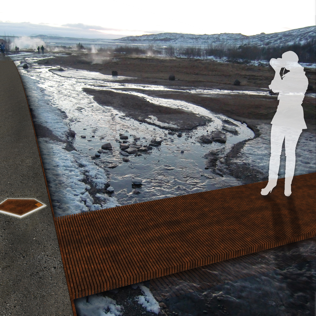
«Kongsstien» is made up of minimal conceptual strategies – lifting the ground somewhat here, placing something lightly on the ground over there – in such a way that the magic of the place is preserved and that future kings may come to visit, be fascinated and leave again, just a little bit wiser.«
The proposal was made in collaboration with Handegaard Arkitektur.
«Kongsstien» – coming as a stranger to a place of such awe, breathing and seething – at Geysir it really feels like you are closer to mother earth as a living, breathing entity, and that you are closer connected to her. To change a landscape like this demands respect, and the changes must reflect and subordinate itself to the existing – if not the Geysir area will loose the uniqueness of its connection to the inner earth. «Kongsstien» is made up of minimal conceptual strategies – lifting the ground somewhat here, placing something lightly on the ground over there – in such a way that the magic of the place is preserved and that future kings may come to visit, be fascinated and leave again, just a little bit wiser.
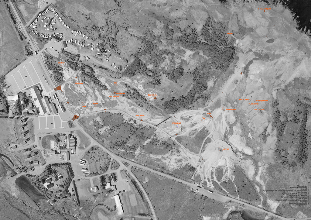
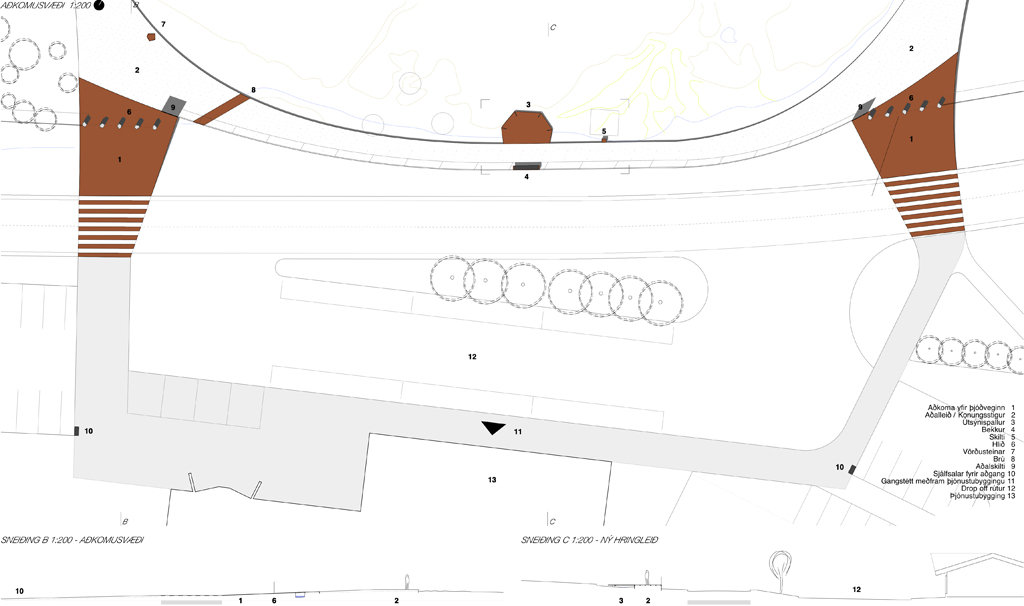
UNDERSTANDING OF PLACE // The Geysir area is today characterized by step-by-step development and no unifying impression that greets people. The extent of the conurbation is in the competition proposal defined by a new public bath on the western edge of the main parking, partially entrenched in the landscape. This gives a two-sided access and thereby better use of the main parking lot. The entrance to the parking lots are placed as early as possible, both to the east and west. This enhances the public flows securitywise, and leaves a minimum of vehicular traffic at the crossing points at Geysistofa. The two main entrances to the geothermal area defines a shared space, where vehicular traffic and pedestrians are mingled.
The deserted farm Laug can be redeveloped for tourist rental with a strong focus on environmentally friendly tourism as a self-sufficient summer cottage complex. This would be a perfect advertising board for similar deserted farms in more spectacular secluded locations, self sufficient in the same way. The fence surrounding the geothermal area is repositioned to the west, when the shortcut from the camping site is integrated into the pedestrian system of the geothermal area. The fence is also repositioned so that you can reach the top of the Laugarfell mountain still within the perimeters of the geothermal area. Ticket sales are handled either in the service centre or through ticket machines on the southern side of the road close to the parking lots, thus preventing large concentrations of people out in the road. Automated entrance control with ticket scanning further facilitates quick access to the geothermal area on the northern sid of the road. The ticket system will be adapted to the national strategies for payment at tourist sites in the Icelandic landscape – i e the «naturpass».
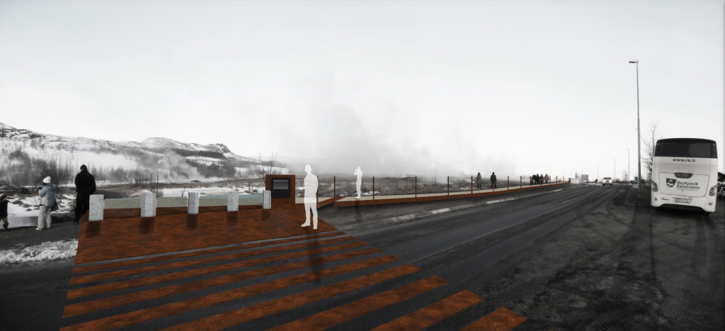
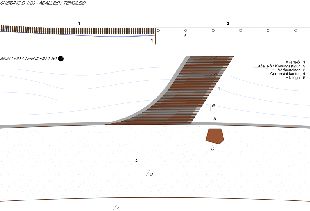
ENTRANCE TO THE AREA // From the big parking lots you move as a pedestrian unhindered along the service centre, whether you come from the west or the east you can choose either between the existing or the new entrance. Two «surfaces» come down from the geothermal area and invite you in, made from cor-ten steel plates embodied in the asphalt. They split to individual lines as pedestrian crossing and continues into the geothermal area as one continuous plate. The new crossings defines a quieter zone where toueist busses has their drop-off zones and vehicular traffic in general is kept on the pedestrians terms. A continuous pedestrian zone binds the two crossings and the entrance to the service center together, as well as the materiality of the shared space is changed to slow speed and indicate that the pedestrians are prioritised.
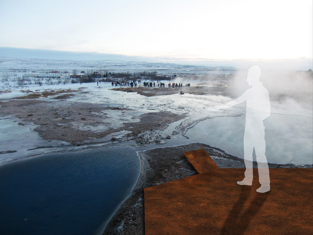
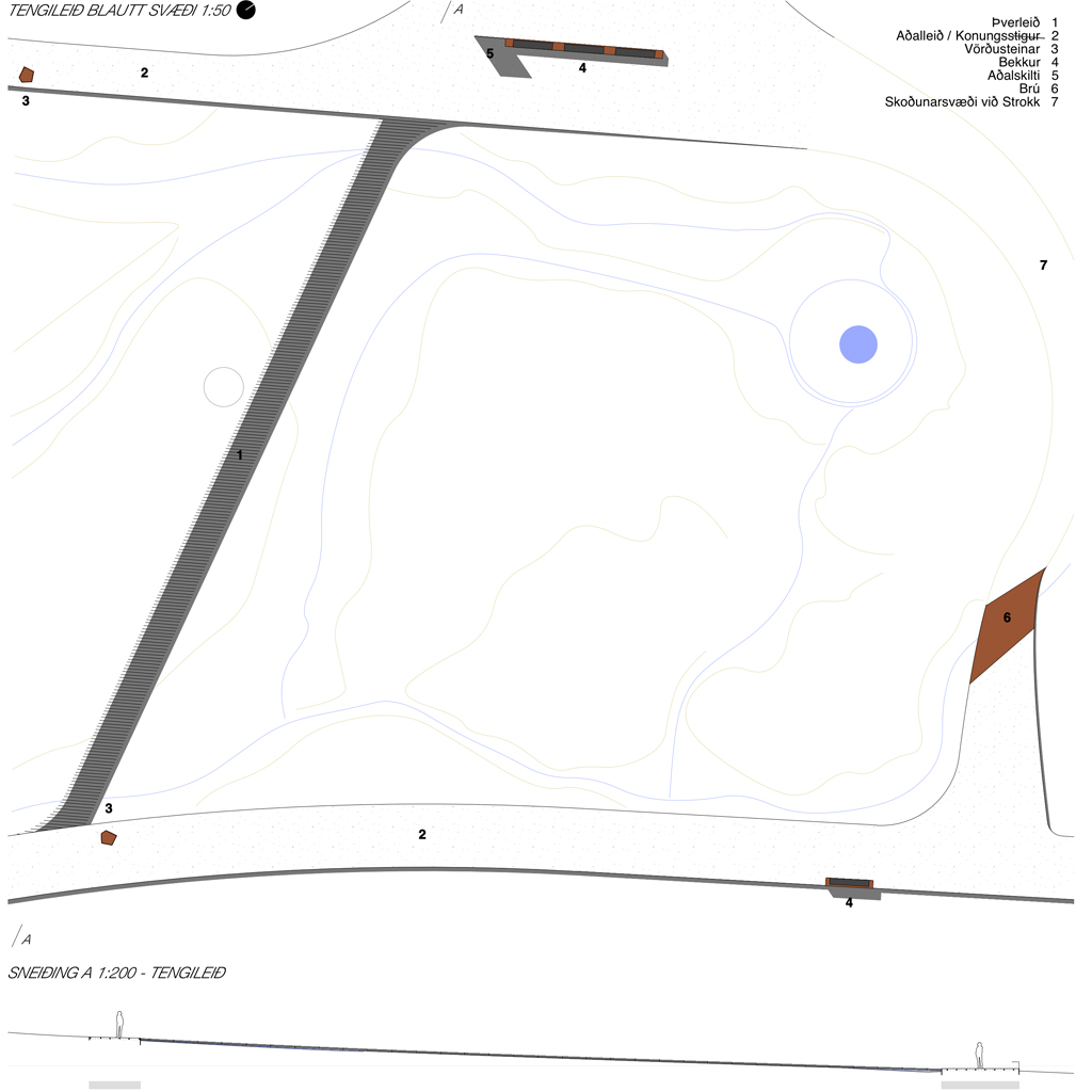
FLOWS WITHIN THE GEOTHERMAL AREA // Within the geothermal area is established a new ring road, and by positioning the new pathway on the northern side of Thykkvihverir you get a better overview of all the smaller pots here. In addition the new pathway gives access to the hotter springs which you can´t reach today. The ring road is water heated and ice-free, and makes a relief to the ground made of sandblasted concrete, with aggregate of the same colour as the on-site sand and gravel. A secondary crossing path is executed as a cor-ten steel rib structure also water heated by the flexible pipes which binds the ribs together – these ribs functions as an ice-free carpet laid out over the wet areas and let the overflowing water run through while you pass over dry. The paths to view-points, Laugarfell top and the Kings rocks are visually enhanced with abstract cor-ten «rocks» as guiding rocks as markers.
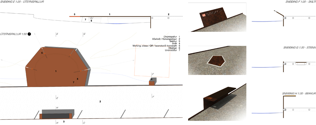
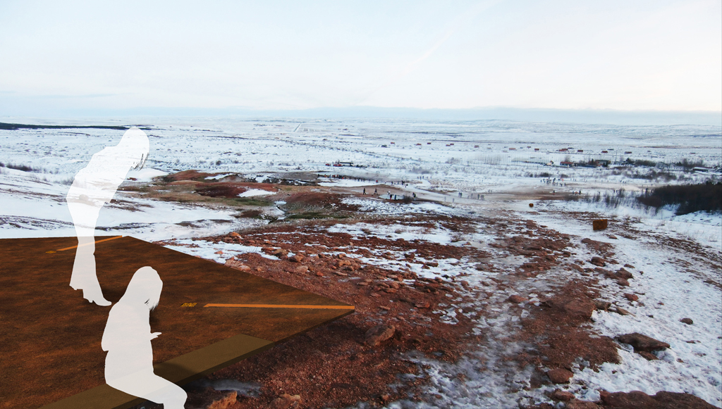
ELEMENTS // The ring road: surface relief in sandblasted concrete with cor-ten steel edge as guide line. / Secondary crossing: «carpet» og cor-ten steel rib structure./ Sightseeing platforms: Cor-ten steel plates with slits marking directions to springs / Bridges: Cor-ten steel plates covering small streams where they cross the ring road./ Main sign: Bigger cor-ten steel plate vertically extended from the edge with area description. / Signs: Tilted signs made of cor-ten steel plates, attached to the edge. / Bench: Cor-ten steel edge extended and bent to facilitate sitting with a / Guiding rocks, embodied: embodied cor-ten plates with edge illumination / Guiding rocks, free standing: Cor-ten abstract rocks along secondary paths / Fence towards the road: The Cor-ten edge is extended to form pillars for steel mesh.
The new ring road forms a new loop which circumferes the hot spring Blesi. All elements attaches themselves to this new main loop – the sightseeing platforms are bent out from the edge, the benches and signs are extended and bent from the edge, the guiding rocks are embodied into the road surface or placed onto the terrain guiding along the secondary paths. The crossing south of Strokkur is also a highly visible secondary path, which functionally lets the water run through and under it. The pathways to Konungshver / viewpoint / Konungssteinar / Háihver / Laugarfell are less used and the free-standing rocks are enough to guide the visitors through the landscape and prevent damage to the terrain.
MATERIALITY // Few, but robust lasting materials, are chosen to blend into the surroundings and avoid greater visual impact. «Gravel roads» made from sandblasted in-situ concrete, with aggregate of locally collected materials to further blend into the landscape. The ring road is percieved as a relief to the slightly undulating landscape. Water pipes run through the pathways, thus preventing ice and slippery conditions for unprepared visitors. Cor-ten steel as contrast material makes up the edges / wetland paths / sightseeing platforms / signs / benches and guiding rocks. Flexible water pipes are also used as the structural element for the cor-ten steel ribs of the wetland pathways, and underneath the sightseeing platforms. Fluorescent painted text and lines / QR-codes as visual contrast for signage and presentations.
COMMUNICATION AND EDUCATION STRATEGY // To avoid many large signs with plenty of text scattered around the area, it is suggested to place one main sign at the entrance / exit points which explains more thoroughly the geology and history of the geothermal area with written text. At every point of interest there are instead placed name-signs with an additional unique QR-code that takes you to a web-site with more specific information about each hot spring. Such an interactive digital solution is also more suitable to use educationally, where for instance school classes can use the web-site both for preparation and post visit assignments and information gathering. The QR-codes are painted on transparent plastic plates, embodied into the cor-ten metal signs, so that they are changeable if needed.

